[I stand corrected! See comments. The border shown is the pre-1967 line. Edits below. -RS]
Thanks to the Chapel Hill News for publishing the Hidden Voices walking tour of downtown Chapel Hill and Carrboro. In today's paper there was also a map, which they seem to have wisely chosen not to publish online, that showed the points of interest on the tour. It also showed a completely made up historic border between Chapel Hill and Carrboro, as if someone just took a ruler and made a nice straight line from North Greensboro & Pleasant to Cameron & Roberson!
Someone needs to let them know that all of Broad Street is in Carrboro, while all of Graham Street and the entire Pine Knolls neighborhood are in Chapel Hill. This is especially relevant in a discussion of the history of the area.
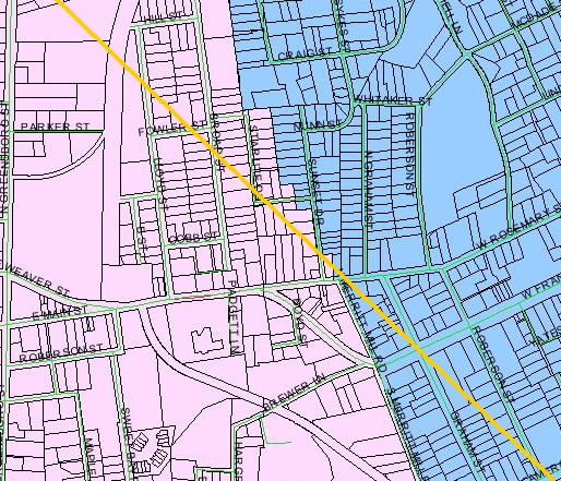
For your reference (and for the graphics staff at the CHN) here is a map depicting the actual border between the towns. Blue is Chapel Hill, lavender is Carrboro. (How appropriate - I didn't even pick those colors!) The yellow line is the newspaper's pretend border.
More Information:
Issues:
Comments
They were probably using the 11 O'Clock line, which was spelled out in the Treatry of Calvander (1831) after the border war. The actual border is based on the original foundations of The Great Wall of Carrboro, excavated and then detailed by Professor Venable in his book Ancient Empires of the Piedmont.
Actually, the current zig-zag boundary between Chapel Hill and Carrboro dates back only to 1967, before that time, Carrboro was square (not be confused with the opposite of hip). I think the line shown on the CHN map was an attempt to show the pre 1967 Chapel Hill/Carrboro boundary, which was the boundary in effect at the historical era of the tour sites! That being said, the straight line is not exactly in the right place, but close.
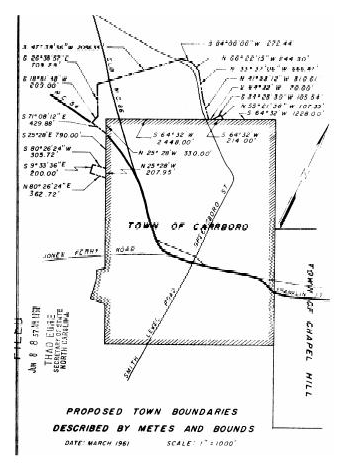
Here are the 1961 boundaries
http://www.secretary.state.nc.us/imaging/Dime/IVTIFF_12751173.pdf (the little jog on the west was annexed in 1960, before that it was a perfect square)
then in 1967 the General Assembly moved some territory in Northside and the Knolls from Chapel Hill to Carrboro with the agreement of the two towns
http://www.ncleg.net/enactedlegislation/sessionlaws/html/1967-1968/sl1967-410.html setting the current zig zag border (interestingly, the 1967 act contains a reference to Carrboro as the "Town of Venable", which was its original corporate name)
Carrboro had a new survey done in 1968 to reflect the 1967 legislation, see
http://www.secretary.state.nc.us/imaging/Dime/IVTIFF_12751180.pdf
It's great to have you here, Gerry.
Around the time we were dedicating the Century Center, I tried and tried to pin down a few facts about West End / Venable / Carrboro. There's not much in the history books. One factoid has West End originally incorporated as Venable in 1911, named for UNC President Venable. That makes sense. They only named a building after him on campus. Nice that he had a whole town named after him for a few minutes before Julius Shakespeare Carr brought in electricity. At least he didn't call it Carrtown!
Catherine DeVine
There's a picture of the original post office in the Wilson Library archives. We used the photo in a long-ago Carrboro Day newspaper insert. It looks like a Wild West saloon -- a freestanding building with a few dusty men posing outside. But the sign clearly says Post Office.
Carrboro historian Richard Ellington believes the building was located on Main Street where Bank of America now stands. He says, "I think somebody told me that."
Too much of Carrboro's rich history is undocumented.


Here is the original graphic from the CHN for comparison. Click on image to see full size.